This hike climbs over a series of ridges in the northern portion of Harriman State Park. It includes sections of two long-distance trails – the Appalachian Trail, which extends for over 2,150 miles from Maine to Georgia, and of the Long Path, which runs for about 350 miles, from the George Washington Bridge to near Albany, New York. The hike offers only limited views, especially in the summer...
Hike Description:
This hike climbs over a series of ridges in the northern portion of Harriman State Park. It includes sections of two long-distance trails – the Appalachian Trail, which extends for over 2,150 miles from Maine to Georgia, and of the Long Path, which runs for about 350 miles, from the George Washington Bridge to near Albany, New York. The hike offers only limited views, especially in the summer, when the leaves are on the trees. But blueberry bushes are plentiful along the entire route, and hikers can enjoy the ripe blueberries during July and August.
To begin the hike, find the bridge over the stream at the southern end of the Silvermine Picnic Area (marked with a sign “Welcome to the Silvermine Boat Launch”). Here, you will see a yellow blaze of the Menomine Trail, which you will be following for the first part of the hike. Cross the bridge, then turn left onto a dirt road, passing two park maintenance buildings. Just before reaching Silvermine Lake, turn right, then bear left when you reach a brown-painted cinder block building. Here, the yellow blazes resume. Follow the trail into the woods on a rocky footpath.
Soon, you’ll again reach the shore of the lake. In a short distance, the trail widens to a woods road – the old Bockey Swamp Road. Before Silvermine Lake was created in 1934, the road followed the edge of what was then known as the Bockey Swamp. When the lake was filled with water, the northern portion of the road was submerged, and the old road emerges from the lake here.
Continue ahead on the level woods road. After passing the southern end of the lake, the road begins to climb, and it soon reaches a T-intersection. Continue to follow the yellow blazes of the Menomine Trail, which turns left onto another woods road. After crossing the inlet of the lake, the road begins to climb, first gradually, then more steeply.
At the top of the rise, the stone William Brien Memorial Shelter is on the left. Overnight camping is permitted here, and the shelter is frequented by thru-hikers on the Appalachian Trail, who hope to complete the entire trail from Georgia to Maine (if you’re lucky, you might meet a thru-hiker along the trail!). Built in 1933 as the Letterrock Shelter, the shelter was renamed in 1973 in memory of Mr. Brien. This is a good place to take a break.
When you’re ready to continue, proceed for about 50 feet ahead on the Menomine Trail to a junction with the white-blazed Appalachian Trail (A.T.) and the red-dot-on-white-blazed Ramapo-Dunderberg Trail (R-D). Turn right onto the joint A.T./R-D, which climbs to one of the peaks of Letterrock Mountain, with a dense understory of blueberries. You might get a glimpse of the Hudson River from the crest of the rise, but most views are obscured by the trees. The A.T./R-D descends from the peak, then levels off through dense mountain laurel.
After crossing the intermittent Bockey Swamp Brook, the A.T. diverges from the R-D. Bear left, leaving the A.T., and continue to follow the red-dot-on-white-blazed R-D Trail. The R-D now begins a steady, gradual climb of Goshen Mountain. At the top, it crosses the summit ridge. Upon reaching the 1,320-foot summit at the southern end of the ridge (with a limited west-facing view), the trail turns sharply right and begins a steady descent.
Soon, the R-D levels off on a woods road. It follows the road for about half a mile, then – with Tiorati Brook Road visible ahead in the distance – turns sharply right. The trail now follows an old woods road that has, for part of the way, narrowed to a footpath. After a level stretch, the trail begins a gradual descent to Seven Lakes Drive.
The R-D crosses Seven Lakes Drive and continues on a wide dirt road that leads into Youmans Flats, a park maintenance area. To the left, the ridge of Fingerboard Mountain may be seen across a wetland. At the entrance to the maintenance area, the trail turns left along a chain-link fence and begins to follow a grassy woods road. Soon, the road bears left, crosses a wooden bridge over a stream, and begins a gentle climb.
In a short distance, you’ll reach a junction where the A.T. crosses. Here, the R-D turns left and once again begins to run jointly with the A.T., but you should proceed straight ahead, leaving the R-D, and continue along the grassy woods road. Although unmarked, the road is clear and easily followed, even in several places where it is partially overgrown by vegetation and has narrowed to a footpath.
When you reach the crest of the rise, watch for a cairn (pile of rocks) on the right. Turn sharply right here onto the aqua-blazed Long Path, which heads north, following the ridge of Stockbridge Mountain. The trail climbs steeply over a rise, then descends. After a level stretch, the Long Path again begins to climb, eventually reaching the 1,340-foot summit of the mountain – the highest point of the hike. The summit is marked by a large rock ledge, with a limited view to the west through the trees.
The trail continues north along the ridge of the mountain, with some ups and downs. In about a mile, as the trail descends, you’ll notice a large cantilevered rock – known as Hippo Rock – to the left. Just beyond, you’ll reach a junction with the yellow-blazed Menomine Trail.
Turn right and follow the Menomine Trail, which descends on an old woods road. It soon bears left and levels off, then turns right and resumes its descent. Near the base of the descent, you’ll pass through a pine grove and cross the outlet of Lake Nawahunta. The trail briefly parallels the lake, then bears right onto the Nawahunta Fire Road, which it follows to Seven Lakes Drive.
The trail crosses the road and reenters the woods. After crossing the entrance road to an abandoned parking area for the former Silvermine Ski Area (this parking area is now overgrown with vegetation), the trail follows a dirt road through a picnic area and soon reaches the parking area where the hike began.
Publication: Submitted by Daniel Chazin on 07/28/2006


This loop hike follows portions of the Appalachian Trail and the Long Path, passing Silvermine Lake and Lake Nawahunta.
41.295607, -74.05961
Orange Co., NY
8 mi
4.5 hrs

Buy Book: Circuit Hikes in Harriman
Buy Map: Harriman-Bear Mountain Trails Map
Avenza App Map: Harriman-Bear Mountain 119
Hike Checklist:
Whether you are going for a day hike or backpacking overnight, it is good practice to carry what we call The Hiking Essentials. These essentials will help you enjoy your outing more and will provide basic safety gear if needed. There may also be more essentials, depending on the season and your needs.
The Essentials
Hiking Shoes or Boots
Water - Two quarts per person is recommended in every season. Keep in mind that fluid loss is heightened in winter as well as summer. Don't put yourself in the position of having to end your hike early because you have run out of water.
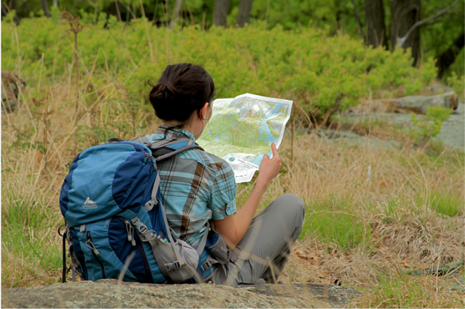
Map - Know where you are and where you are going. Many of our hiking areas feature interconnecting network of trails. Use a waterproof/tear-resistant Tyvek Trail Conference map if available or enclose your map in a Ziplock plastic bag. If you have a mobile device, download Avenza’s free PDF Maps app and grab some GPS-enhanced Trail Conference maps (a backup Tyvek or paper version of the map is good to have just in case your batteries die or you don't have service). Check out some map-reading basics here.
Food - Snacks/lunch will keep you going as you burn energy walking or climbing. Nuts, seeds, and chocolate are favorites on the trail.
Sunscreen and insect repellent
Rain Gear and Extra Clothing - Rain happens. So does cold. Be prepared for changing weather. Avoid cotton--it traps water against your skin and is slow to dry. If you are wearing wet cotton and must return to your starting point, you risk getting chills that may lead to a dangerous hypothermia. Choose synthetic shirts, sweaters and/or vests and dress in layers for easy on and off.
Compass - A simple compass is all you need to orient you and your map to magnetic north.
Light - A flashlight or small, lightweight headlamp will be welcome gear if you find yourself still on the trail when darkness falls. Check the batteries before you start out and have extras in your pack.
First Aid Kit - Keep it simple, compact, and weatherproof. Know how to use the basic components.
Firestarter and Matches - In an emergency, you may need to keep yourself or someone else warm until help arrives. A firestarter (this could be as simple as leftover birthday candles that are kept inside a waterproof container) and matches (again, make sure to keep them in a waterproof container) could save a life.
Knife or Multi-tool - You may need to cut a piece of moleskin to put over a blister, repair a piece of broken equipment, or solve some other unexpected problem.
Emergency Numbers - Know the emergency numbers for the area you're going to and realize that in many locations--especially mountainous ones, your phone will not get reception.
Common Sense - Pay attention to your environment, your energy, and the condition of your companions. Has the weather turned rainy? Is daylight fading? Did you drink all your water? Did your companion fail to bring rain gear? Are you getting tired? Keep in mind that until you turn around you are (typically) only half-way to completing your hike--you must still get back to where you started from! (Exceptions are loop hikes.)
Check the weather forecast before you head out. Know the rules and regulations of the area.
The Leave No Trace Seven Principles
Plan Ahead and Prepare
- Know the regulations and special concerns for the area you'll visit.
- Prepare for extreme weather, hazards, and emergencies.
- Schedule your trip to avoid times of high use.
- Visit in small groups when possible. Consider splitting larger groups into smaller groups.
- Repackage food to minimize waste.
- Use a map and compass to eliminate the use of marking paint, rock cairns or flagging.
Travel and Camp on Durable Surfaces
- Durable surfaces include established trails and campsites, rock, gravel, dry grasses or snow.
- Protect riparian areas by camping at least 200 feet from lakes and streams.
- Good campsites are found, not made. Altering a site is not necessary.
- In popular areas:
- Concentrate use on existing trails and campsites.
- Walk single file in the middle of the trail, even when wet or muddy.
- Keep campsites small. Focus activity in areas where vegetation is absent.
- In pristine areas:
- Disperse use to prevent the creation of campsites and trails.
- Avoid places where impacts are just beginning.
- Pack it in, pack it out. Inspect your campsite and rest areas for trash or spilled foods. Pack out all trash, leftover food and litter.
- Deposit solid human waste in catholes dug 6 to 8 inches deep, at least 200 feet from water, camp and trails. Cover and disguise the cathole when finished.
- Pack out toilet paper and hygiene products.
- To wash yourself or your dishes, carry water 200 feet away from streams or lakes and use small amounts of biodegradable soap. Scatter strained dishwater.
- Preserve the past: examine, but do not touch cultural or historic structures and artifacts.
- Leave rocks, plants and other natural objects as you find them.
- Avoid introducing or transporting non-native species.
- Do not build structures, furniture, or dig trenches.
- Campfires can cause lasting impacts to the backcountry. Use a lightweight stove for cooking and enjoy a candle lantern for light.
- Where fires are permitted, use established fire rings, fire pans, or mound fires.
- Keep fires small. Only use sticks from the ground that can be broken by hand.
- Burn all wood and coals to ash, put out campfires completely, then scatter cool ashes.
- Observe wildlife from a distance. Do not follow or approach them.
- Never feed animals. Feeding wildlife damages their health, alters natural behaviors, and exposes them to predators and other dangers.
- Protect wildlife and your food by storing rations and trash securely.
- Control pets at all times, or leave them at home.
- Avoid wildlife during sensitive times: mating, nesting, raising young, or winter.
Be Considerate of Other Visitors
- Respect other visitors and protect the quality of their experience.
- Be courteous. Yield to other users on the trail.
- Step to the downhill side of the trail when encountering pack stock.
- Take breaks and camp away from trails and other visitors.
- Let nature's sounds prevail. Avoid loud voices and noises.
The Trail Conference is a 2015 Leave No Trace partner.
(c) Leave No Trace Center for Outdoor Ethics: www.LNT.org.
Directions to Trailhead :
Take N.J. Route 17 north to the New York State Thruway and take the first exit, Exit 15A (Sloatsburg). Turn left at the bottom of the ramp onto N.Y. Route 17 north, and continue through the Village of Sloatsburg. Just past the village, turn right at the traffic light, following the sign for Seven Lakes Drive/Harriman State Park. Continue along Seven Lakes Drive for about 12 miles to the Silvermine Picnic Area, on the right side of the road (the Silvermine Picnic Area is 2.1 miles beyond the Tiorati Circle). Park in the large parking area near the entrance (a parking fee is charged on weekends in the summer).
TRAIN TRANSPORT :
Not availableBUS TRANSPORT :
Not availableShare Your Experience
SUPPORT
 Support the trails with a donation!
Trail Conference volunteers maintain trails in this hike.
Trip Reports
rate experience December 22, 2018
A hike less traveled
Just did this hike this afternoon. Very wet on the trails and windy. Wind chill had to be in the 20s. A very well thought out circuit hike. The only place where it is hard to navigate is near the Brien shelter on the Menomime Trail, turning right onto AT/Ramapo-Dunderberg. I've done this hike before, and I have had to backtrack because I missed the turn. The ramapo-dunderberg trail is not very well marked in some spots on this hike (the painting on some of the trees are so faded that one has to squint to make them out). AT is well-marked. The section of the Long Path is sparsely blazed--it could use more frequent blazes. Overall, a good hike with lots of gentle climbs and sections of old unmarked roads make this interesting. An interesting lollipop loop could be done by adding on Baileytown Road all the way to Twin Lakes and back. that would add another 2 or so miles.
March 10, 2018
Late Feb. hike
Amazing how the lakes have thawed out so quickly. Only 3 weeks ago folks were walking out on the lakes and fishing , now only some smaller ponds have any ice . ..and it's only February!..
The weather was actually perfect for hiking and really enjoyed getting outdoors for a late winter hike. The trails and terrain were varied and the climbs and distance were just enough to make this hike a valid workout. Even with the trees being bare, the views were nothing exceptional but the hike is still interesting and the varied terrain makes it nice.
One warning. I passed right by the start of the yellow blazed Menomine trail along the Long Path trail and climbed a steep bluff to the Stockbridge shelter before realizing my error and backtracking to the trail head. The markings are off to the right not far below Hippo Rock...or to the left if you're backtracking ...
June 16, 2014
hike directions
<P>Daniel,</P>
<P>We took this hike this past weekend as well as another and can say that any messups were our own and if you don't see a marker within a few minutes, you should know enough that you did something wrong. What, however, is confusing about this hike is the junction at the Brien shelter. Maybe this has changed over time as hikers have redefined the main trails. I would currently describe the yellow Menomine Trail as passing directly in front of the shelter. I would ALSO describe the AT trail as passing directly in front of the shelter making the two trails overlap for that short distance. So, if you pass the shelter on the left and continue 50 feet down the yellow trail, you've technically passed the AT junction you wanted to turn right on. There was a red on white maker for the RD trail that you will see but many campers use that area as well and you might end up walking through their camp. Even if you do that, you can get confused because there are some other white looking markers that you can confuse for the AT markers that take you to a small spring. We followed those and then saw no more markers wondering where we got lost.. We were later told by another hiker who agreed that those markers may look white but are technically real light blue and actually do just take you to that spring and that's the end of them. </P>
<P>So, the right turn you want really is slightly BEFORE the shelter. Hopefully, this will help other hikers.</P>